2.5D tracks
Tracks (TrackGenerator, tutorial at Generating a Batch of Tracks) are
2.5D, exactly like gate courses: the plan-view layout comes
from the proven 2D centerline generators and XPBD relaxer, and altitude (Z) is
layered on afterwards as a first-class elevation stage. The result is a genuine
3D road — every Track boundary point carries a vec3f position, distances
and speed profiles account for real climbing/descending, and a heightfield can be
baked for an external physics solver — without giving up any of the 2D pipeline’s
layout quality, determinism, or (at the default settings) its exact numeric output.
Why 2.5D
The 2D track pipeline — resample to constant spacing, XPBD-relax, inflate into a
constant-width band — is a plan-view (XY) computation and stays bit-identical
to the pre-elevation era. Altitude is added as a separate stage that runs on the
already-offset 2D borders, before the lift to vec3f. Concretely, in
inflate_warp (track_gen/_src/warp_pipeline.py) the stage order is:
resample -> frame + curvature -> arc length -> winding -> offset (outer/inner)
    -> Z PROFILE (writes per-point z) -> validity -> LIFT to vec3f
    -> [non-flat only] recompute 3D tangent + true 3D arc length
On the default z_profile="flat" with z_base=0.0 the lift writes a constant
z = 0.0 and the arc-length/tangent tables are left untouched from the 2D
stages — bit-identical to the legacy planar path (this is golden-verified; see
tests/test_golden_migration.py). On any other profile, the per-point altitude
computed by warp_zprofile.apply_z_profile (the same profiler used by
gate courses) is applied to outer/center/inner
together, and a follow-up kernel (_track_frames3_k) recomputes the tangent and
the true 3D arc length from the now-3D centerline.
Altitude profiles
TrackGenConfig.z_profile selects the altitude family — the identical four
options and knobs as gate courses (both configs are read
through the same apply_z_profile entry point). All four write every real
centerline point and NaN the padding’s xy; z carries the flat path’s z_base
(0 by default) at every slot, padding included. The z_* knobs below are
inert for the profiles they do not apply to.
|
Altitude model |
Knobs |
|---|---|---|
|
Planar. Every real point sits at |
|
|
Independent hill heights: |
|
|
Correlated rolling terrain: a grade-capped walk over the
|
|
|
Smooth periodic terrain with harmonic control: decided per-point (not
knot-based) as a sum of |
|
z_control_points is not itself a z_profile — it is the knot-count knob
used by the uniform and random_walk rows above: the number of
arc-spaced altitude control knots (default 10, must be ≥ 3) those two
profiles interpolate between. It is inert for flat (constant altitude,
no knots) and for noise (per-point, decided by frequency via
z_noise_harmonics instead of knot count).
Note
z_max_step is a grade, not an absolute step. Under the knot stage
(uniform, random_walk) it bounds |dz| per unit plan-view arc
length between adjacent knots (ds = perimeter / z_control_points),
not between adjacent resampled points — so, for a fixed z_max_step, the
walk can now swing over a larger total altitude range than it could when
the cap applied point-to-point. This is an intentional, user-visible
change from the previous per-point grade cap: it is what fixes the
washboard texture described below, at the cost of z_max_step alone no
longer bounding how much altitude changes over any one resampled segment.
A profiled batch can also be rejected outright: z_valid_grade is the maximum
allowed |dz|/ds grade between adjacent points, with ds measured along the
plan-view (XY) arc length — not the 3D lifted length. z_valid_grade = 0
(the default) disables the check; any steeper adjacent pair marks the whole env
invalid, on top of the unchanged 2D validity gate (turning number, thickness,
width floor, optional border self-intersection). Because a monotone-cubic
segment can overshoot its secant slope by up to 3× (see Smoothness below),
z_max_step alone does not bound the realized per-point grade on uniform
or random_walk — z_valid_grade is what actually gates realized
steepness, and should be set (non-zero) whenever a hard grade limit matters.
Note
Migration note for existing z_valid_grade users. The knot-based
walk (above) raised the realized per-point grade to roughly 1.5×
z_max_step (up from roughly 1.08× under the old per-point-capped walk).
If you already had z_valid_grade set to a fixed value roughly in the
1.1×-1.7× range of your z_max_step, batches will now return noticeably
fewer valid envs than before, because more adjacent-point grades cross that
threshold. Measured with random_walk, 64 envs: at z_max_step=0.3,
z_valid_grade=0.35 went from 63/64 valid to 21/64; at 0.40, from 64/64
to 40/64; at 0.45, from 64/64 to 58/64. The default z_valid_grade=0
(check disabled) is completely unaffected — no action needed if you never
set it. If your z_valid_grade falls in that affected range, raise it
(comfortably above ~1.7× z_max_step to recover the old acceptance rate)
or lower z_max_step.
Smoothness
For uniform and random_walk, altitude is decided at only
z_control_points arc-spaced knots per env and interpolated between them
with a periodic monotone cubic (Fritsch-Carlson-limited tangents, wrapping at
the seam so the loop closes with no discontinuity). Two consequences follow
directly:
Exact bounds, no post-clamp. Each knot’s altitude is guaranteed to fall in
[z_min, z_max]before interpolation even runs (it comes from the same per-point profile kernel, run over the knots instead of the resampled points):uniformdraws each knot directly in that range, andrandom_walkclamps its walk to it. The monotone construction then guarantees the interpolant never leaves the interval spanned by its two bracketing knots. So the whole curve stays within[z_min, z_max]exactly, with no additional clamping step required or applied.Resolution and bumpiness are decoupled. Raising the track’s resample resolution samples the SAME underlying road more finely; it does not add new altitude decisions or introduce new bumps, because the road between knots is a fixed cubic, not a fresh per-point draw. This is what eliminates the washboard texture that a per-point
uniform/random_walkdraw produces at high resample density — the previous per-point grade cap capped local jitter but never removed it.
That decoupling only holds while z_control_points stays well below the
resampled point count; a very large z_control_points starts to
reintroduce, knot by knot, the same per-point jitter this feature is meant to
replace (measured: z_control_points=200 on a ~95-point track produces 65
direction changes along the profile).
The one caveat: monotonicity bounds the interpolant’s range, not its local
slope. A monotone-cubic segment’s realized grade can reach up to 3× its
knot-to-knot secant slope (the same Fritsch-Carlson limiter that kills
overshoot also sets that bound), so z_max_step — which only shapes the
walk at the knots — does not bound the steepest per-point grade actually
realized between them. If a hard steepness limit matters for your use case,
set z_valid_grade (non-zero) rather than relying on z_max_step alone;
it is checked against the realized per-point grade after interpolation, on
every adjacent pair.
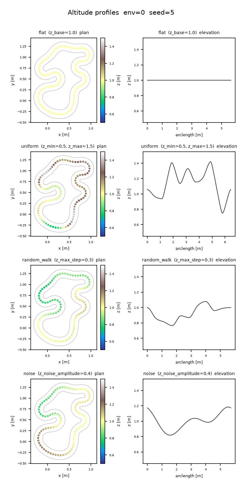
The four altitude profiles on the SAME plan-view layout and seed, rendered
by viz/plot_z_profiles.py (z_base=1.0, z_min=0.5, z_max=1.5,
z_max_step=0.3, z_noise_amplitude=0.4, z_control_points=10).
flat is constant; uniform, random_walk, and noise are all
smooth rolling curves (never jittery), but visibly distinct in character —
independent knot-to-knot swings, a correlated single-basin walk, and
harmonic periodicity respectively. Regenerate with
python viz/plot_z_profiles.py --out docs/_static/z-profiles.png --seed 5.
Level cross-sections, and why plan-view collision stays valid
The elevation stage lifts outer, center, and inner together: at
every centerline index i, all three boundary points share the same z
(_lift_track_zvar_k — “level cross-sections”). Two consequences fall out of
this directly:
The per-point half-width recovery
‖outer[i] - center[i]‖still works unmodified: sinceouter[i]andcenter[i]share az, the vertical component cancels and the norm is exactly the plan-view (XY) half-width, lifted track or not.Out-of-bounds collision stays a plan-view check.
CollisionChecker(Out-of-bounds & obstacle collision) drops every boundary point’szbefore comparing against the query box (it only ever readswp.vec2f(p[0], p[1])off thevec3finputs) — so an agent’s XY position is checked against the SAME road cross-section regardless of the track’s altitude at that point. This is deliberate: elevation never changes where the drivable band is in plan view (the offset stage that producesouter/innerruns entirely in 2D, before the Z profile is even computed — see the stage order above), so a collision engine that only understands XY keeps working exactly as before.
One v1 limitation carries over from the general 2.5D design and is listed in full on the gate courses page: plan-view self-crossings are still rejected for tracks (unlike gates, a track’s plan view is not allowed to cross itself). The other 2.5D limitation is specific to this page and the spec’s non-goals: the elevation stage does not add any tube/banking geometry — a lifted track is a ribbon of level cross-sections, not a banked surface.
3D distance semantics
Once a track is lifted, every distance-measuring utility in the package reads the LIFTED (3D) geometry rather than its plan-view projection, with one exception (collision, above) that is plan-view by design:
Track.arclen/Track.length— cumulative and total arc length along the centerline. For the default flat profile this is the plan-view length; for a non-flat profile it is the TRUE 3D length of the lifted centerline, strictly greater than the plan-view length whenever the profile is non-constant (a hilly loop is longer in 3D than in plan view).Track.tangent— for a non-flat profile this is a true 3D central difference over the lifted centerline (_track_frames3_k), not the 2D tangent.Track.normal, by contrast, is computed BEFORE the lift and stays the plan-view left-normal atz = 0— it is not re-derived from the 3D tangent, sonormal = (-tangent.y, tangent.x, 0)no longer holds literally on a lifted track (the XY direction still matches, buttangentis 3D-unit-length, so its XY projection alone is sub-unit).track_gen.props.PropSamplerandtrack_gen.checkpoints.CheckpointSamplershare the same boundary-scanning kernel (_scan_boundary_k), whose snap spacing and reportedPropSet.step/length(points and segments modes alike) are measured along the true 3D polyline — identical to the planar length wheneverz = 0, but a genuine 3D chord/arc-step on a lifted track.track_gen.localize.curvature()keeps its turn-angle NUMERATOR exactly plan-view (unaffected by grade on its own), but its denominator does pick up a z contribution: a plan-view turn taken on a graded section reads a slightly smaller magnitude than the same turn flat, and a steep enough grade reversal (a sharp crest or dip) on an otherwise straight section can register as a spurious sharp turn.speed_profile()inherits thatkappaas its corner-speed limit, but its accel/brakedsis the true 3D segment length, so the distance budget for accelerating out of / braking into a corner accounts for the real climbing/descending path length.
PropSet.position
track_gen.props.PropSet (Boundary props) already carries
vec3f positions: on a flat track every prop’s z is 0, and on a lifted
track each prop’s z tracks the boundary elevation at its sample point (an
on-curve sample in "points" mode, a chord midpoint in "segments" mode) —
no code change is needed to place props on an elevated road; the sampler was
built vec3f-native alongside the rest of the 2.5D work.
Breaking changes
PropSet.position changed from vec2f to vec3f as part of the 2.5D
work. Downstream code that reshapes it as .reshape(-1, 2) will break;
update it to .reshape(-1, 3).
Heightfield
For external physics solvers that want a grid rather than a polyline,
track_gen.heightfield.HeightFieldBaker bakes each env’s road surface
into a square height grid. It is not driven directly in normal use: set
CourseConfig.heightfield_resolution (track mode only, >= 8) and the
Course facade builds and re-bakes it on every
generate() alongside the SDF bake, exposed as course.heightfield:
from track_gen.course import Course, CourseConfig

course = Course(CourseConfig(mode="track", gen=config, seeds=0,
                             checkpoint_spacing=0.6,
                             heightfield_resolution=96))
course.generate()
hf = course.heightfield.bake()          # HeightField; re-bakes from the CURRENT batch
grid = hf.height.numpy().reshape(config.num_envs, 96, 96)  # [E, res, res], row-major (y, x)
Every texel takes the road z of the NEAREST centerline cross-section by
plan-view distance: on-road texels get the exact road surface, and off-road
texels continue the nearest edge’s height outward, so the surface has no cliff
at the road edge. Flat tracks bake a constant z_base sheet; invalid or
degenerate envs (Track.valid[e] == 0 or fewer than 3 real points) bake
NaN across the whole env. The per-env world AABB is the plan-view band’s
bounding box plus padding (AUTO: 10% of the env’s larger extent, matching the SDF
baker’s convention), and texel (x, y) centers map to world coordinates as:
world = lo + ((x, y) + 0.5) / res * (hi - lo)
with lo/hi the per-env [E] vec2f AABB corners (HeightField.lo/
HeightField.hi) and res the grid resolution (HeightField.res).
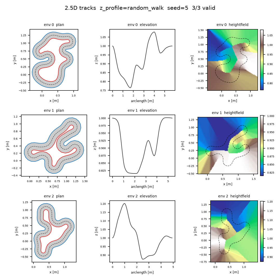
Three tracks rendered by viz/plot_tracks_3d.py
(z_profile="random_walk", z_base=1.0, z_min=0.2, z_max=2.0,
z_max_step=0.3). Each row is one env: plan view (filled band + outer/inner
borders + dashed centerline), elevation profile (arc length vs. centerline
z), and the baked heightfield (imshow, extent from lo/hi, with the
plan-view centerline overlaid) — the heightfield’s ridge tracks the same
climbs and dips visible in the elevation panel, at the same plan-view
location. Regenerate with
python viz/plot_tracks_3d.py --out docs/_static/tracks-25d.png --envs 3 --seed 5.
See also
3D gate courses — the same elevation stage applied to gate sequences, plus the
gate_alignframe-tilting choice and the 3DCourseLineruntime.Generating a Batch of Tracks — the end-to-end track-generation recipe.
The Course facade — the
Coursefacade, includingCourseConfig.heightfield_resolution.Boundary props — boundary prop sampling, vec3f-native on lifted tracks.
Track-frame localization —
curvature()andspeed_profile(), whose behavior on lifted tracks is detailed above.Out-of-bounds & obstacle collision — the plan-view out-of-bounds checker.